
- 400
- 500
- 600
- 700
- 800
- 900
- Rouran 400–554
- First Göktürk 552–630
- Tang rule 630–682
- Second Göktürk 682–744
- Uyghur 744–840
- Kirghiz 840–924
- Huns 370–469
- Western Göktürk 552–659
- Türgesh 699–766
- Karluk 766–800
- Khazar 650–969
The eastern khaganate fell in a single winter. The western one took twenty years, and the Tang took it from the south.
The oases first
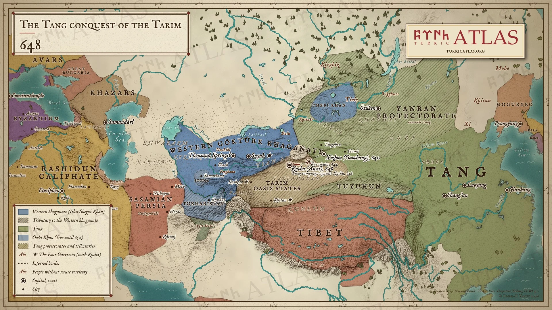
The Tang began with the oasis states of the Tarim rim and the road east of it. They took Gaochang in 640 and then the towns of the basin one after another. Those places were not the khaganate, but the khaganate lived on them. A steppe power in the west drew its revenue from the trade that crossed its territory and from the settled principalities that paid it. Therefore the Tang took the payers before they took the power.
The condition of the khaganate
The Tang finished a khaganate that had been in civil war on and off since the murder of Tong Yabgu about 630. The Chinese sources use the name Ten Arrows for the ten divisions of the western tribes. This structure could produce a khan, and it produced several at once.
Ashina Helu was the last of these khans. He had been in Tang service and went back to the steppe. There he made himself khan over the Ten Arrows. He fought the Tang for six years.[1] The end came in 659, when Tang forces ran him down west of the Chu and sent him to Chang’an.[1]
The Tang settlement
The Tang did not annex the west. They did there what they had done in the east after 630. They set the tribes under protectorates and gave them khans of the Ashina to be governed through. The device was the same loose-rein system, applied to a country the Tang could not garrison.
The settlement reached beyond the steppe. In 661 the Tang decreed sixteen area commands in the lands west of the Pamirs, under the protectorate of Anxi at Kucha. Most of them existed only on paper.[2] One of them was set over the Hephthalites. Its seat was the city of Huolu, and it had fifteen prefectures under a Great Khan.[2] Where Huolu lay is not known. Some scholars doubt that the command took in Badakhshan at all.[3]
The settlement lasted about as long as it had in the east. Within two generations the Türgesh had made themselves the power of Semirečʹe without asking anyone. The appointed khans had no following.
Comparison with the eastern conquest
The eastern khaganate was a state with one khan, one royal camp and one army. When the Tang took those in 630, nothing was left to fight. The western khaganate was a confederation of ten divisions. Therefore it had to be taken ten times. As a result, the eastern conquest is dated to a season and the western one to two decades.
References
Sources
- Jiu Tangshu (Old Book of Tang), juan 194
- Xin Tangshu (New Book of Tang), juan 215 (after Jiu Tangshu)
Literature
- Édouard Chavannes, Documents sur les Tou-Kiue (Turcs) occidentaux (1903)
- Peter B. Golden, An Introduction to the History of the Turkic Peoples (1992)
- Emre-E. Yavuz, The Gokturk Empire: 2nd Edition (2025)
- Josef Markwart, Wehrot und Arang. Untersuchungen zur mythischen und geschichtlichen Landeskunde von Ostiran (1938)
- Albert Herrmann, Die Hephthaliten und ihre Beziehungen zu China (1925)
What links here2
- Persons
- Irbis Shegui Khan
- States
- Tang
Cite this article
Yavuz, Emre-E. “The Tang conquest of the western Khaganate, 640–659.” Turkic Atlas, revised 8 November 2026. https://turkicatlas.org/conflicts/tang-conquest-of-the-western-khaganate/
Last revised: 8 November 2026

