
- 400
- 500
- 600
- 700
- 800
- 900
- Rouran 400–554
- First Göktürk 552–630
- Tang rule 630–682
- Second Göktürk 682–744
- Uyghur 744–840
- Kirghiz 840–924
- Huns 370–469
- Western Göktürk 552–659
- Türgesh 699–766
- Karluk 766–800
- Khazar 650–969
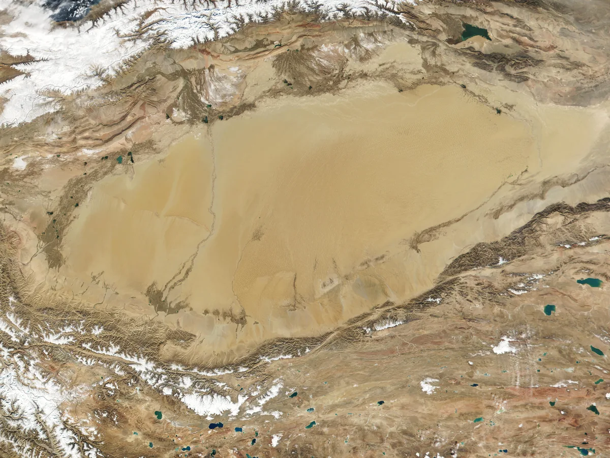
The Tarim Basin is the great desert basin south of the Tian Shan and north of the Kunlun. It covers about a million square kilometres. The Taklamakan takes the centre, and the oasis cities lie on the rim.[1] In Göktürk history it is the country of the tributary cities. The Göktürks took it in the 550s and held it for a century as a source of revenue and a road. They lost it to the Tang in the 640s, and they never governed it.
The basin and its passes
The rim was a ring of autonomous city-states that had become entrepôts for the goods carried between China and Rome. The most important in the sixth century were Gaochang, that is Turfan; Kucha and Aksu in the north; Kashgar and Yarkand in the west; Khotan in the south; and Loulan in the east. All of them lay at the edges of the desert, where anyone crossing from east to west or north to south had to stay.[1] Sanskrit texts of the northern rim show that the kingdoms there had kings of their own. The leaves are dated on palaeographic grounds to about 600, some of them older.[2] They name four kingdoms of the rim. From west to east these are Hecyuka, Bharuka and Kucha, and beyond Kucha Agni, the Karashahr of the Chinese Yanqi. Hecyuka is identified with Uč-Turfan. The kings of Kucha and of Agni bore the title īśvara mahārāja, “lord and great king”.[3] Of the four names, Kucha and Hecyuka come from the local language. Agni and Bharuka are Indian.[4] Bharuka may be the name of a settlement founded by merchants from the Indian port of Bharukaccha.[5] Whoever formally ruled the basin took, as a rule, a share of all the income from buying and selling, quite apart from the taxes of the inhabitants. The cities were only part of the entrepôts of the silk roads, but they were the most important ones in the contests of the ancient and early medieval great powers. Three passes give entry. The Jade Gate in the east was built under the Han emperor Wudi in the decades after 121 BC.[6][7] Kashgar in the west is the traditional gateway between the basin and the Pamirs. The Dzungarian Gate in the north is the corridor by which the Göktürks came. The Dzungaria article deals with the gate.
In Han and Jin times
The oasis states appear in the Han Shu first as subjects of the Xiongnu. The Rizhu king, who commanded the Xiongnu on the western border, kept a Commandant of Slaves over the Western Regions. The Commandant lived between Yanqi, Weixu and Yuli. He taxed the states and drew his wealth from them.[8] In the second year of Shenjue, which is 60 BC, the Rizhu king went over to the Han with his people.[8][9] Zheng Ji, the Han officer who protected the states west of Shanshan, received him. The court made Zheng Ji protector of the northern road as well. From then the office was called Protector-General, duhu. The Commandant of Slaves was abolished. The Xiongnu could no longer come near the Western Regions.[8]
The Protector-General sat at Wulei, a small state of 110 households and 300 men.[8] It lay 350 li east of Kucha and close to the Han field-officers at Quli. The land was fertile and, in the words of the Han Shu, central to the Western Regions.[8] Wulei is placed in two ways. One puts it at Chadir, some fifty kilometres east of Bugur. The other puts it at Bugur itself.[10]
The first Han presence in the basin was agricultural. After Li Guangli’s campaigns against Dayuan the Han raised posts from Dunhuang west to the Salt Marsh. At Luntai and Quli they settled several hundred farmer-soldiers under a commissioner. The commissioner guarded the fields and stored grain for the envoys travelling abroad.[11] Slips from a station of the Dunhuang frontier show what such an envoy needed. They give six sheng of millet a day for each of the eighty-seven soldiers of an escort, and rations for two young men recommended by a letter of the envoy to Yarkand.[12] The slips belong to about 95 BC by their neighbours.[12]
The Han Shu says that two roads led out into the Western Regions from the Jade Gate and the Yang Pass. The southern road ran from Shanshan along the Southern Mountains to Yarkand and over the Pamirs to the Yuezhi and Parthia. The northern road ran from the court of the Former Jushi along the Northern Mountains to Kashgar and over the Pamirs to Dayuan, Kangju and Yancai.[8] By the time of the Weilüe, in the third century, there were three. The Weilüe, quoted in the commentary to the Sanguozhi, adds a middle road. It led from the Jade Gate through the White Dragon Dunes to the old town of Loulan and on to Kucha. The Weilüe also adds a new northern road. This road went by Gaochang and joined the middle road at Kucha.[13] By one calculation the middle road was the shortest of them, about 1,700 kilometres from the Yang Pass to Kashgar against 1,900 by the southern and 2,100 by the northern road.[14]
Chinese slips and papers from the Lop Nor, of the third and early fourth century, show the garrison and the courts of the rim at work. A man from Yanqi wrote a letter on paper. Fragments name the king of Yanqi, and three sheng were issued to an envoy of Khotan.[15] At Niya, in the south of the basin, eight wooden tags in Chinese, without a date, went with presents of precious stones among the royal family. The king’s mother sent one to the king, and further tags name the wife of the heir and a princess.[16]
Before the Göktürks
For the early sixth century little is recorded of the political situation in the basin. The Hephthalites and the Rouran can be assumed to have shared influence over the cities, in a constant contest for control. Shortly before the Göktürks arrived, the Hephthalites had wrested part of the basin from the Rouran, whose vassals they had been for a time. The extent of Hephthalite rule, which was indirect, is not clear from the sources.[1] The Liang Shu says that the Hua, as it calls the Hephthalites, were once a small people under the Rouran. They grew strong and marched against the states beside them: Persia, Panpan, Jibin, Yanqi, Qiuci, Shule, Gumo, Yutian, Jupan and others. They opened more than a thousand li of land.[17] This list has been taken for the frontier of the Hephthalite realm, with nearly all the oasis states of the basin subject to it. The Liang Shu itself speaks only of the campaign and of the land gained.[18] On the same view, the Hephthalites reached their dependent oasis states by the southern Pamir passes, with Wakhan and Tashkurgan as the chief stations.[19] The region and its trading cities had been divided between the two empires. When the Göktürks replaced the Rouran, they regarded themselves as heirs to everything their former overlords had once ruled.
The conquest of the 550s
The Zhou Shu gives the western conquests to Mukan, with the Hephthalites among the peoples he broke. The Sui Shu’s closing judgement says that from Mukan the Göktürks ruled from the old Eastern Hu lands in the east to the whole of the Wusun country in the west. Neither text names a Tarim city.[20] Istemi’s army, which by one estimate reached Lake Balkhash in 555, subdued the basin at almost the same time.[1] It came through the Dzungarian Gate against the city-states of the rim rather than across the desert, and took control of Kucha and the other city-states. There the Göktürks behaved as they did on the steppe. They integrated foreign peoples with their settlements into the realm and left internal affairs internal. They imposed no cultural demands, and they forced neither the Old Turkic language nor its script on anyone.[1] The same account has the Göktürks fight the Hephthalites on a second front in the western cities of the basin, at Kashgar for instance, though no records survive. It also finds the conquest pictured in a wall painting of the Kizil caves near Kucha, dated to 552. The painting shows the local rulers of Kucha leading armoured newcomers with face-masks into a building. A different explanation, a century older, is that the painting of armoured riders at a city gate in the Cave of the Painters at Qizil shows the distribution of the relics of the Buddha. The princes of the cities then come armed to claim their share. Turkic Atlas describes it under Kucha. Whether both explanations concern the same painting is not certain.[21] Turkic Atlas carries the war in the west under the Hephthalites and under the battle of Bukhara.
Under the western Göktürks
The Sui Shu’s account of the western Göktürks begins with Apa. In it Kucha, the Tiele, Yiwu and the Hu of the Western Regions all adhere to them. Under Heshana it names two lesser khans: one north of Chach to control the Hu states and one north of Kucha at a place called Yingsuo.[22] When the Tiele rose in 605, Yiwu, Gaochang and Karashahr went over to their Mohe Khan.[22] Shegui won them back. The Xin Tang Shu sets his court at Sanmi mountain north of Kucha. It says that the states west of the Jade Gate were mostly in service to him. The opening of the Tang chapter places the western Göktürks with Kashgar as their southern bound.[23] The wealthy inhabitants of the basin count, with the Khitan and the Sogdians, among the peoples whose contributions secured the state and the rule of the Ashina.[1] What passed through is visible in the ground. The principal Sasanian hoard found in China was hidden at Ulugh Art, at the very opening of the pass that joins Ferghana and the Tarim by the Alai. It held 947 Sasanian and Arab-Sasanian coins and thirteen gold bars, what a merchant or refugee reaching China from Central Asia in the seventh century could carry.[24] Sogdians living at Turfan, Karashahr and Hami left ossuaries, inscriptions and a fire temple.[24]
The Tang conquest
In the civil wars of the Ten Arrows the basin changed hands with the khans. The Xin Tang Shu says that Irbis Ishbara Yabgu Khan, set up by the Nushibi and recognised by Taizong, had Kucha, Shanshan, Qiemo, Tokharistan, Karashahr, Chach, Kesh, Kushaniya, Maimargh and Samarkand as his subjects. His rival the Üç Tuğlu Khan took Tokharistan and raided Yizhou. The protector of Anxi, Guo Xiaoke, beat him with two thousand light horse. His siege of Tianshan with Chuyue and Chumi troops failed. When Irbis Shegui Khan asked for a Tang bride, Taizong demanded the five states of Kucha, Khotan, Kashgar, Zhujubo and the Pamirs as the bride-price. The marriage did not take place.[23] The campaign against Kucha followed, in 648 by the Tang annals, with Ashina Helu riding ahead as guide.[1] When Taizong went to war in the Tarim in the 640s he sent Ashina officers with thousands of Chinese to fight the armies of the western Ashina. At the level of the officers the war was therefore Göktürks against Göktürks.[1] Taizong’s successor Gaozong gave the garrisons up when he came to the throne. He did not wish to enlarge the empire’s territory and burden its people. He moved the Anxi protectorate back from Kucha to Xizhou.[25] After Helu’s capture the states that had served him were all made prefectures, as far west as Persia, under the protectorate of Anxi at Kucha. The Four Garrisons were Kucha, Khotan, Kashgar and Karashahr. They had ceased to belong to the western Göktürks well before Helu’s defeat.[26] The Tibetans later took the garrisons west of Karashahr. In 692 Wang Xiaojie and Ashina Zhongjie won them back. Anxi stood at Kucha again, held by thirty thousand Han soldiers.[25] In the eighth century a fifth of the Tang state’s receipts in cloth, more than five million pieces a year, went to the control of the western regions. Considerable quantities of silk therefore reached the basin as the pay of soldiers and officials in all the towns from Dunhuang to Suyab.[24]
After the Göktürks
The Kül Tegin inscription says that the Göktürks of the second khaganate campaigned westward as far as the Iron Gate and the Pearl river. The second khaganate’s attempts on Beiting on the northern slope belong to its own articles. The second khaganate did not hold the basin itself.[27] In the ninth century one of the polities that grew out of the Uyghur diaspora was centred on the oasis cities of the basin. Beshbalik lay in the north, and the Turfan region (Xizhou, Gaochang, Qocho) in the south.[28] The Uyghur kingdom of Qocho kept the name of Gaochang for centuries.[28] In sum, the Göktürks were the patrons of the Tarim basin but did not intervene in its internal affairs. Only when the Chinese of the Tang appeared did the Göktürks have to stand by the oasis cities militarily.[1]
Assessment
The Tarim was the one province of the Göktürk state that paid in coin. The Göktürks took their share, protected the road, and left the cities their kings. That is why it left so little trace in the Göktürk sources. It left much more in the Chinese sources, since the Chinese governed it when they took it.
References
- ^ a b c d e f g h i Yavuz 2025
- ^ Lüders 1930, p. 4
- ^ Lüders 1930, p. 3–4,26–27
- ^ Lüders 1930, p. 27
- ^ Lüders 1930, p. 28
- ^ Chavannes 1913, vi
- ^ Herrmann 1910, p. 117–118
- ^ a b c d e f Han Shu, juan 96
- ^ Chavannes 1913, vii
- ^ Herrmann 1910, p. 38,86
- ^ Han Shu, juan 96; Shiji, juan 123
- ^ a b Chavannes 1913, p. 73
- ^ Sanguozhi, juan 30
- ^ Herrmann 1910, p. 115
- ^ Chavannes 1913, p. 171,195,197–198
- ^ Chavannes 1913, p. 198–200
- ^ Liang Shu, juan 54
- ^ Herrmann 1925, p. 565,568–569
- ^ Herrmann 1925, p. 576–577
- ^ Zhou Shu (Book of Zhou), juan 50; Sui Shu (Book of Sui), juan 84
- ^ Grünwedel 1920, ii 109–111
- ^ a b Sui Shu (Book of Sui), juan 84
- ^ a b Xin Tangshu (New Book of Tang), juan 215
- ^ a b c de la Vaissière 2005a
- ^ a b Jiu Tangshu (Old Book of Tang), juan 198
- ^ Chavannes 1903
- ^ Kül Tegin inscription
- ^ a b Golden 1992
Sources
- Sui Shu (Book of Sui), juan 84
- Xin Tangshu (New Book of Tang), juan 215 (after Jiu Tangshu)
- Zhou Shu (Book of Zhou), juan 50
- Kül Tegin inscription
- Jiu Tangshu (Old Book of Tang), juan 198
- Han Shu, juan 96 (after Shiji)
- Shiji, juan 123
- Sanguozhi, juan 30
- Liang Shu, juan 54
Literature
- Emre-E. Yavuz, The Gokturk Empire: 2nd Edition (2025)
- Albert Grünwedel, Alt-Kutscha. Archäologische und religionsgeschichtliche Forschungen an Tempera-Gemälden aus buddhistischen Höhlen der ersten acht Jahrhunderte nach Christi Geburt (1920)
- Étienne de la Vaissière, Sogdian Traders: A History (2005)
- Peter B. Golden, An Introduction to the History of the Turkic Peoples (1992)
- Édouard Chavannes, Documents sur les Tou-Kiue (Turcs) occidentaux (1903)
- Édouard Chavannes, Les documents chinois découverts par Aurel Stein dans les sables du Turkestan oriental (1913)
- Albert Herrmann, Die alten Seidenstrassen zwischen China und Syrien. Beiträge zur alten Geographie Asiens, Bd. 1 (1910)
- Albert Herrmann, Die Hephthaliten und ihre Beziehungen zu China (1925)
- Heinrich Lüders, Weitere Beiträge zur Geschichte und Geographie von Ostturkestan (1930)
What links here27
- Persons
- Ashina Helu · Ban Chao · Irbis Ishbara Yabgu Khan · Irbis Shegui Khan · Shegui Khan
- States
- Kushan Empire · Shanshan
- Battles & Events
- Battle of Bukhara
- Places
- Aksu · Beiting · Cave of the ancestors · Dzungaria · Gaochang · Jade Gate · Karashahr · Kashgar · Khotan · Kucha · Loulan · Quli · Tian Shan · Wulei · Yarkand
- Peoples
- History of the Turkic peoples · Uyghurs
- Religions
- Buddhism among the Göktürks
Cite this article
Yavuz, Emre-E. “Tarim Basin.” Turkic Atlas, revised 8 November 2026. https://turkicatlas.org/places/tarim-basin/
Last revised: 8 November 2026

