
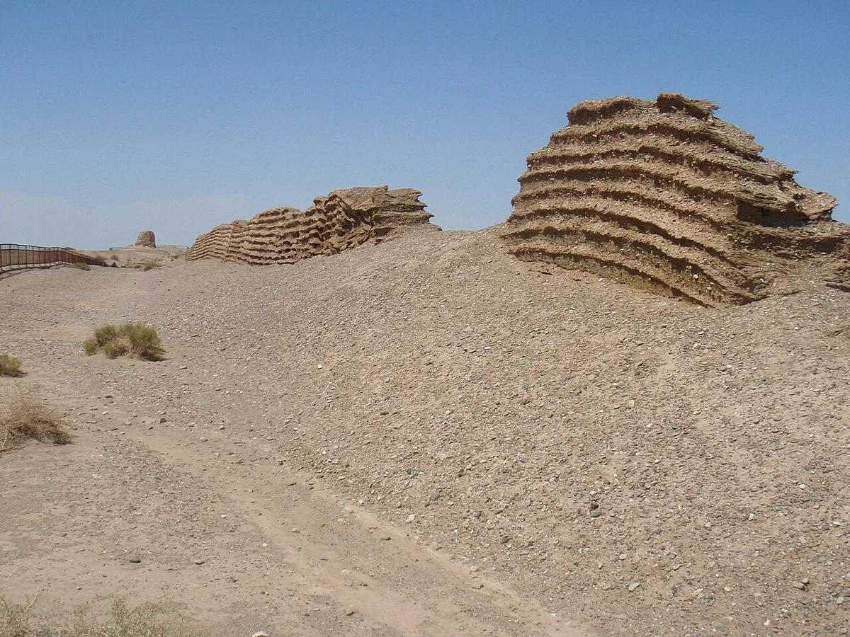
The Jade Gate, 玉門關, in pinyin Yumen guan, was the pass at the western end of the Han frontier, in the country of Dunhuang. The Han Shu says that the Western Regions meet the Han in the east at the Jade Gate and the Yang Pass. It says that the Salt Marsh lies more than three hundred li from the two.[1] Two roads led from them into the Tarim basin. The southern road ran by way of Shanshan, and the northern road ran by way of the court of the Former Jushi.[1] Centuries later, the Tang histories still named the Gate when they said how far the western khan Shegui ruled.[2]
Name
- 玉門關ChineseHan Shu
- Yumen PassEnglish
The name means Gate of Jade. The Han Shu says that Shanshan produces jade and that Khotan has much jade stone.[1] The name is sometimes derived from that trade, because jade was the most precious freight that crossed the sands of Central Asia into China.[3]
Founding
The Jade Gate first appears in the sources as the end of a line. The Shiji says that Zhao Ponu, the marquis of Zhuoye, beat Gushi and took the king of Loulan. After that, the posts and forts of Jiuquan reached as far as the Jade Gate. The Han Shu repeats the sentence.[4] Scholars disagree on the date. Some date this continuous line of posts to 108 BC.[3] A second puts the beginning of the wall at about 110 BC. It dates the name Jade Gate to 105 BC and the posts from Dunhuang to the Salt Marsh to about 95 BC.[5] The Han Shu closes its chapter on the Western Regions with a judgement on Wudi. It says that he set out the four commanderies of Hexi and opened the Jade Gate, so as to cut off the right arm of the Xiongnu.[1] The wars with the Xiongnu that opened the way west are told in The Xiongnu–Han Wars.
The Gate was a barrier as well as a road. Li Guangli brought the beaten remnant of his first army back from Dayuan. The emperor sent men to bar the Jade Gate and threatened with death any soldier who passed it. Li Guangli stopped at Dunhuang.[4] The year was 103 BC.[3][6] The army halted at Dunhuang. For this reason, some scholars put the Gate at that time east of the town. They have the wall carried west after the second campaign of 102 and 101 BC.[7] More than ten thousand men and more than a thousand horses of the second army came back in through the Jade Gate.[4]
The Gate also served as a base behind that army. While Li Guangli marched on Dayuan, the Xiongnu did not dare meet his strong force. They sent riders instead, using the watchers of Loulan, to cut off the Han envoys who followed. Ren Wen, an officer of the army, was stationed at the Jade Gate with troops as a rear guard for Li Guangli. He took prisoners, learned what was planned and reported it.[1] The emperor ordered him to go by the short road, seize the king of Loulan and bring him to court. The king was questioned there. He answered that a small country between great ones could not live in peace unless it served both, and he asked to move his people into Han land. The emperor found the answer honest and sent him home, to watch the Xiongnu for the Han.[1]
The garrison
Aurel Stein found slips of wood along the wall north of Dunhuang. They name a military commandant of the Jade Gate. The earliest is dated to the third year of Taishi, which is 94 BC. Another belongs to the fifth year of Yongguang, 39 BC. The latest is of AD 43, the nineteenth year of Jianwu, and names the commandant of the fortress of the Jade Gate.[8] In a further slip, a man who calls himself assistant to the commandant of the Jade Gate, in Dunhuang commandery, announces that he has taken charge of a post.[9] Labels of stores name two companies of the Jade Gate.[10]
A note in the geographical treatise of the Han Shu is cited for the slips. It puts both the Jade Gate and the Yang Pass on the land of Longle, a county of Dunhuang commandery, and gives each its own commandant.[11]
Position
The Han texts give the Gate no position of its own beyond the county of Longle. They give relations. The Salt Marsh lies more than three hundred li from the Gate, and the traveller who leaves Dunhuang goes out by the Jade Gate and the Yang Pass and on through Shanshan.[12] Three determinations from the early twentieth century work from these relations and from the wall itself. Two of them are the findings of 1910 and 1913 and are given here as such. The third is Stein’s, made at the wall itself in 1907 and 1914, and follows in its own section.
An older view had put the Jade Gate at the gate of the modern frontier wall, 25 km west of Suzhou. The Hou Han Shu text on the road out of Dunhuang showed that both passes lay not far west of Dunhuang.[13] The 1910 determination reckoned the three hundred li to the Salt Marsh at about 130 km. This put the Gate near the 93rd meridian, some 130 km west of Dunhuang.[14] A survey of the wall made in 1907 then allowed a closer analysis. The river that runs along the outside of the wall loses itself in marshes. They begin near the point where the wall turns south-west and run on to its end. There were two easy ways west. One was where the river enters the marshes, at the turn of the wall. The other was where the marshes end, at the end of the wall. The annals speak of two passes. The Jade Gate stood at the first place, 120 km west of Dunhuang. The Yang Pass stood at the second, 140 km west of Dunhuang and south-west of the Jade Gate.[15] From the Gate it was three or four days to the eastern shore of the old Salt Marsh.[5]
The slips allowed the wall to be analysed station by station. Two stretches were built after the second campaign of Li Guangli. The first formed a line across the salt lagoons west of the 94th meridian and rested on the station numbered T. xiv. The second ran further west, to about 93 degrees 30 minutes east, and ended at T. iv. From T. iv, the road went on south-west to the Lop Nor without a continuous wall. The Chinese built small forts at the resting places.[7] By the slips of T. xiv, the Gate stood there by 94 BC. It may have stood at T. iv about 39 BC.[7] On one view, a label of the time of Wang Mang puts it at T. xii.[16]
The excavation at T. xiv
Stein placed the Jade Gate at the ruined fort T. xiv. The few people from Dunhuang who go there to graze their ponies or gather fuel call it Xiaofangpan, the small protected camp.[17] The fort stands on a neck of raised ground that crosses a depression of salt bogs and reed marsh. The road to Lop Nor had to pass over that neck.[17] The fort itself gave no date. The datable finds came from a mound a little to the north, where Stein found a tunnel, a shaft and several refuse heaps in 1907.[18] Eighty of the slips of wood from the mound were edited in 1913, and many more from the shaft had rotted in the damp. The dated ones run from 96 BC to AD 19.[19]
He rested the identification on the slips. The name Yumen stands in ten of the slips from T. xiv, four times with the word for pass. Two more speak of the pass alone. Among the 672 slips published from the whole wall, the name occurs 24 times, and half of those come from this site.[20] A slip of 96 to 94 BC shows the military commandant of Yumen giving an order to an officer over a thousand men.[21] From these slips and from the lie of the ground, Stein concluded that the Gate could be fixed at T. xiv for as long as the Han guarded the western wall.[22] He tested the place against the Jiu Tang Shu, which puts the Yumen pass 118 li north-west of Shouchang.[23] He identified Shouchang with the oasis of Nanhu, and T. xiv lies almost exactly north-west of Nanhu.[23]
A thinner wall, about 1.5 m thick, comes down from the marshes north of the fort. It passes the fort on the west and runs south-south-east toward Nanhu, where Stein placed the Yang pass. He followed it for about 5.5 km beyond the fort, and its bearing points at a ruined tower below the northern edge of the Nanhu fields.[24] Slips found east of this cross wall run to AD 137. Those found west of it stop with the time of Wang Mang.[25] Stein took the cross wall for a retrenchment of the frontier in the early first century AD. In his view, it was drawn to T. xiv so that the old seat of the Gate, and the road that joined it to the Yang pass, could stay where they were.[26] He added that this interpretation of the wall was not proved.[27]
Stein did not put the Gate at T. xiv from the beginning. The Shiji says that the remnant of Li Guangli’s first army came back in 103 BC, and the emperor had the Gate barred against it. The wall beyond Dunhuang is not recorded before the events of 102 and 101 BC.[28] Stein read the sentence to mean that the Gate then stood east of the town.[28] He named two places where it could have stood. One is Shi’erdun, about 24 km north of the district town of Yumen. The other is the defile of the Shule river at Wanshanzi, between Bulongji and Anxi. He left the choice open.[29] He held that the Gate had moved to T. xiv within a few years, wherever it had stood before. The slips of 96 to 94 BC show it there by 96 BC at the latest.[30]
In 1912 Stein had put the Gate of the first two centuries AD at T. xiv and had called the earlier position undecided. He had suggested the camp at the western end of the wall, T. iv, as the most likely place for the original Gate.[31] In 1921 he read that camp as a depot where the road to Loulan left the line of the wall, and kept the Gate at T. xiv.[32] In 1928 he again called the Gate’s place at T. xiv in Han times established.[33] The same volume allows that the defile at Wanshanzi may once have held a gate station corresponding to Yumen. He found that the lie of the ground gave this some support.[34]
The determination of 1913 allows that the Gate stood later at T. iv, about 39 BC. It takes a label of the time of Wang Mang as placing it at T. xii.[35] Stein does not follow it. Two labels from the tower T. xii.a name a company “of Yumen”. He took this to show that the Gate commanded these outposts, about 8 km from T. xiv. He found the plateau at T. xii too narrow and its marsh water too salt for a headquarters.[36]
Stein could not say how long the Gate stayed at T. xiv. A letter of AD 312 from Loulan still mentions departure from the Jade Gate pass. He left undecided whether the station then stood at T. xiv or nearer Dunhuang.[37] Faxian crossed the desert about AD 400 and does not name the Gate.[37] The next notice is Xuanzang’s. Stein understands his biography as putting what was then called the Jade Gate north of the old town of Guazhou. It stood on the left bank of the Shule river and not far from the present town of Anxi.[37] He looks for the five beacon towers beyond it on the road from Anxi to Hami.[37] The Gate of Xuanzang’s day had thus moved from the Han site.[38] He concludes from the Jiu Tang Shu passage above that people still remembered the old site in Tang times.[37] A text from Dunhuang of the ninth or tenth century says that the Yang pass is the ancient Jade Gate. It says that the frontier gate was afterwards moved east of Shazhou. Stein counts the first statement an error. He counts the second a record of the move that Xuanzang’s biography already presupposes.[39] A passage of the Tang annals names Jinchang as the place of the Yumen frontier station in AD 610. Chinese antiquarians look for it east of Anxi.[40] In late medieval times, a barrier much farther east took the place of the Jade Gate. Stein names Jiayuguan as its modern successor.[41]
The roads
The roads that left the Gate changed with the centuries. The Weilüe, which the Sanguozhi quotes, was written between 239 and 265.[42] It counted three roads into the Western Regions from the Jade Gate of Dunhuang, where there had been two. The southern road went by the Qiang country over the Pamirs to the Great Yuezhi. The middle road went past the Dragon Dunes to old Loulan, on to Kucha and the Pamirs. The new northern road went north-west from the Gate and avoided the sands and the dunes. It came out north of Wuchuan, 五船, at Gaochang on the border of Jushi, the seat of the Wuji colonel. There it turned west to join the middle road at Kucha.[43]
The Han Shu also names the Jade Gate. It says that a new road in the land of the Rear Jushi came out north of Wuchuan and led to the Jade Gate. The road was shorter. The Wuji colonel Xu Pu wished to open it, to save half the distance and avoid the White Dragon Dunes. Gugou, the king of the Rear Jushi, disliked the plan, since his land would become a stage on the road. He refused to give evidence on the border with the Xiongnu and was put in chains. In the end he fled to the Xiongnu.[1] The road is dated to the years AD 1 to 6.[44]
The Wei Shu gives an account of the Taiyan era. It counts four roads into the Western Regions where there had been two. Two of them began at the Jade Gate and crossed the Flowing Sands. One went west for 2,000 li to Shanshan. The other went north for 2,200 li to Jushi.[45]
Closing the Gate
The Gate could be shut against a man as well as an army. In the Han Shu, a king named Tangdou had his land beside the great Chishui Qiang. He fought them in repeated raids and did not win. He asked the Protector-General Dan Qin for help, but Dan Qin did not come in time. Tangdou, in distress and bitter against him, went east to the Jade Gate. The Gate would not take him in. He fled with his wife and more than a thousand of his people to the Xiongnu. The Han Shu places the affair in the time when Wang Mang held power at court.[1]
Under the Later Han, the court weighed closing the Gate for good. The Hou Han Shu says in the biography of Ban Yong that the ministers had mostly judged it right to close the Jade Gate and so give up the Western Regions. Ban Chao’s son argued against it. In his speech he said that after the Tibetan revolt the Xiongnu had sent envoys to the oasis states and demanded all taxes that had fallen due and not been paid. They raised the sums and gave a very short term.[46][47] The court restored a camp of three hundred men at Dunhuang and set a deputy colonel for the Western Regions there.[46] In the chapter on the Western Regions, the same court, under Dowager Deng, is shown unable to stop the raids of the northern Xiongnu and Jushi on Hexi. Councillors then wished to close the Jade Gate and the Yang Pass to end the trouble.[48]
West of the Jade Gate
The phrase outlived the Han. The Cefu yuangui says that in the time of Lü Guang of the Later Liang, Lü Guang sent his son Fu to hold Gaochang. Fu held the title of commander of all armies west of the Jade Gate and protector-general of the Western Regions.[49] The Zizhi tongjian has the Sui give Xue Shixiong in 608 the title of commander of the Jade Gate road for the campaign against Yiwu. The army went out through the Jade Gate.[50] In 611, the Sui Shu says, the emperor sent Pei Ju to the town of Jinchang at the Jade Gate pass, to send word to the beaten western khan Heshana.[51] The account of that year is in The Fall of Heshana Khan.
Xuanzang left China without leave in 629.[52] His biography says that the road ran through a pass of that name. It stood on the Hulu river, more than fifty li north of Guazhou. The river could not be forded, and the road had to go by the Gate, the throat of the western border. Beyond it lay five beacon towers, each a hundred li from the next, and then the desert of Moheyan on the border of Yiwu.[52] The pilgrim came to the river at night and saw the Jade Gate in the distance. He and his guide crossed ten li upstream of it, on a bridge of felled trees.[52] The biography does not say whether this Gate stood where the Han Gate had stood.[52]
The Tang histories use the Gate as a measure of the west. The Tongdian and the Jiu Tang Shu say that Shegui, once he was khan of the western Göktürks, widened the realm to the Golden Mountain in the east and to the sea in the west. All the states west of the Jade Gate served him, they say. He became the rival of the northern Göktürks and set his court at Sanmi Mountain north of Kucha.[53] The Xin Tang Shu has the same sentence, with one change. It says that many of the states west of the Jade Gate served him, and that he stood level with the eastern Göktürks.[54] The Xin Tang Shu rewrites the Jiu Tang Shu here, and the passages in the Tongdian and the two histories go back to one account. The Han Shu had bounded the Western Regions in the east by the same Gate and the Yang Pass. The Tang phrase therefore takes its measure from there.
In the second month of 843, Zhao Fan reported that the Kirghiz were attacking the protectorates of Anxi and Beiting. He urged that an army go to their aid.[55] Li Deyu advised against it. In peacetime, he said, the road to the west had run from Hexi and Longyou out through the Jade Gate. Beyond it lay prefectures and counties of the state, all held in strength. Since the troubles, Hexi and Longyou had fallen to the Tibetans. The other way to Anxi and Beiting lay through the Uyghur land. The Uyghur state was destroyed, and no one knew whether its land now belonged to the Kirghiz.[55] On his account, the road out of the Jade Gate had been closed to the Tang since Hexi and Longyou were lost.[55]
References
- ^ a b c d e f g h Han Shu, juan 96
- ^ Tongdian, juan 199; Jiu Tangshu (Old Book of Tang), juan 194; Xin Tangshu (New Book of Tang), juan 215
- ^ a b c Chavannes 1913, vi
- ^ a b c Shiji, juan 123; Han Shu, juan 61
- ^ a b Herrmann 1910, p. 118
- ^ Herrmann 1910, p. 119
- ^ a b c Chavannes 1913, vi–vii
- ^ Chavannes 1913, p. 71,95,107
- ^ Chavannes 1913, p. 42
- ^ Chavannes 1913, p. 126,133
- ^ Chavannes 1913, p. 42,93
- ^ Han Shu, juan 96; Hou Han Shu, juan 88
- ^ Herrmann 1910, p. 78–79
- ^ Herrmann 1910, p. 79
- ^ Herrmann 1910, p. 80
- ^ Chavannes 1913, p. 133
- ^ a b Stein 1921, p. 683
- ^ Stein 1921, p. 684–688
- ^ Stein 1921, p. 688
- ^ Stein 1921, p. 689
- ^ Stein 1921, p. 686,689
- ^ Stein 1921, p. 670,691
- ^ a b Stein 1921, p. 621
- ^ Stein 1921, p. 691–692
- ^ Stein 1921, p. 694
- ^ Stein 1921, p. 694–696
- ^ Stein 1921, p. 695
- ^ a b Stein 1921, p. 726
- ^ Stein 1921, p. 726–727
- ^ Stein 1921, p. 728
- ^ Stein 1912, p. 117–118,122,137
- ^ Stein 1921, p. 638
- ^ Stein 1928, p. 308
- ^ Stein 1928, p. 374–375
- ^ Chavannes 1913, vi–vii,133
- ^ Stein 1921, p. 670,680
- ^ a b c d e Stein 1921, p. 733
- ^ Stein 1921, p. 732–733
- ^ Stein 1921, p. 624,734
- ^ Stein 1928, p. 375
- ^ Stein 1921, p. 696,735
- ^ Herrmann 1910, p. 50
- ^ Sanguozhi, juan 30
- ^ Herrmann 1910, p. 123
- ^ Wei Shu, juan 102
- ^ a b Hou Han Shu, juan 47
- ^ Ögel 2015, p. 341
- ^ Hou Han Shu, juan 88
- ^ Cefu yuangui, juan 990
- ^ Zizhi tongjian (Comprehensive Mirror in Aid of Governance), juan 181
- ^ Sui Shu (Book of Sui), juan 84
- ^ a b c d Life of Xuanzang, juan 1
- ^ Tongdian, juan 199; Jiu Tangshu (Old Book of Tang), juan 194
- ^ Xin Tangshu (New Book of Tang), juan 215
- ^ a b c Cefu yuangui, juan 994
Sources
- Shiji, juan 123
- Han Shu, juan 61, 96 (after Shiji)
- Hou Han Shu, juan 47, 88
- Sanguozhi, juan 30
- Wei Shu, juan 102
- Sui Shu (Book of Sui), juan 84
- Zizhi tongjian (Comprehensive Mirror in Aid of Governance), juan 181 (after Wei Shu, Zhou Shu, Sui Shu and Bei Shi)
- Life of Xuanzang, juan 1
- Cefu yuangui, juan 990, 994 (after Tongdian and Jiu Tangshu)
- Tongdian, juan 199 (after Sui Shu and Zhou Shu)
- Jiu Tangshu (Old Book of Tang), juan 194
- Xin Tangshu (New Book of Tang), juan 215 (after Jiu Tangshu)
Literature
- Édouard Chavannes, Les documents chinois découverts par Aurel Stein dans les sables du Turkestan oriental (1913)
- Albert Herrmann, Die alten Seidenstrassen zwischen China und Syrien. Beiträge zur alten Geographie Asiens, Bd. 1 (1910)
- Aurel Stein, Serindia: Detailed Report of Explorations in Central Asia and Westernmost China (1921)
- Aurel Stein, Ruins of Desert Cathay: Personal Narrative of Explorations in Central Asia and Westernmost China. Vol. II (1912)
- Aurel Stein, Innermost Asia: Detailed Report of Explorations in Central Asia, Kan-su and Eastern Iran. Vol. I (1928)
- Bahaeddin Ögel, Büyük Hun İmparatorluğu Tarihi II (2015)
What links here11
- Persons
- Lady Xiang · Shegui Khan
- States
- Shanshan
- Battles & Events
- Fall of Heshana Khan (611)
- Places
- Dunhuang · Gaochang · Jiuquan · Kucha · Sanmi Mountain · Tarim Basin · Yiwu
Cite this article
Yavuz, Emre-E. “Jade Gate.” Turkic Atlas, revised 8 November 2026. https://turkicatlas.org/places/jade-gate/
Last revised: 8 November 2026


