Zugänge

Atlas

Karten der Steppenreiche und ihrer Nachbarn als Tafeln, der Zeit nach. 68 Karten von 215 v. Chr. bis 842. Eine Tafel schlägt sich in voller Breite auf, mit ihrer Unterschrift, ihren Jahren und den Artikeln, in denen die Karte steht.

Diese Seite und das Menü sind deutsch. Ein Teil der Artikel gibt es auch auf Deutsch, die übrigen sind englisch und als englisch gekennzeichnet.

Die türkischen StaatenTafel unter den Karten

Xiongnu und Xianbei

um 215 v. Chr. – um 1557 Karten

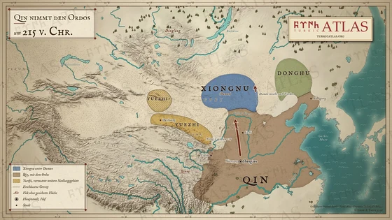
  1. Map of East Asia around 215 BC: Qin with the Ordos taken by Meng Tian, the Xiongnu under Duman north of the Yellow River, the Donghu in the east and the Yuezhi between Dunhuang and the Qilian mountains, with a second reading in the Tian Shan © Emre-E Yavuz 2026
    um 215 v. Chr.Tafel I Qin nimmt den Ordos
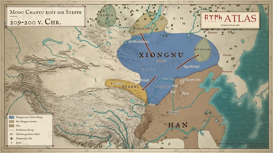
  2. Map of East Asia from 209 to 200 BC: the Xiongnu under Bagatur from the Ordos to Lake Baikal, the Wuhuan, Dingling and Gekun as their subjects, the campaigns against the Donghu, the Yuezhi and the northern peoples, the Han in China and the siege of Baideng © Emre-E Yavuz 2026
    209–200 v. Chr.Tafel II Modu Chanyu eint die Steppe
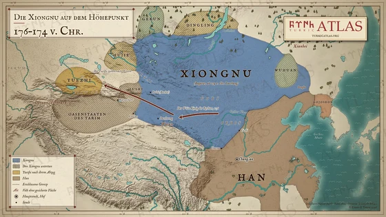
  3. Map of East Asia from 176 to 174 BC: the Xiongnu at their greatest extent from the Tarim to the land of the Donghu, the oasis states, Jushi, the Hujie, Dingling, Gekun and Wuhuan as their subjects, the Wise King of the Right against the Yuezhi and the Yuezhi moving west to the Ili, with the Han and Gojoseon © Emre-E Yavuz 2026
    176–174 v. Chr.Tafel III Die Xiongnu auf dem Höhepunkt
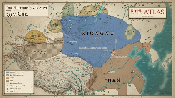
  4. Map of East Asia in 133 BC: the Xiongnu under Junchen with the Ordos and the Hexi corridor, their subjects from the Tarim to the Wuhuan, the Yuezhi on the Ili, the Han, and the march of the chanyu towards Mayi, where three hundred thousand Han lie in ambush, and his withdrawal © Emre-E Yavuz 2026
    133 v. Chr.Tafel IV Der Hinterhalt von Mayi
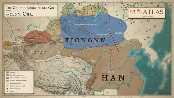
  5. Map of East Asia around 100 BC: the Xiongnu north of the Gobi with the Tarim oasis states, Jushi, the Hujie, Dingling and Gekun as their subjects, the Han with the Ordos and the Hexi corridor, the Wuhuan subject to the Han, the Wusun and the Da Yuezhi, and the campaigns of 119 BC © Emre-E Yavuz 2026
    um 100 v. Chr.Tafel V Die Xiongnu nördlich der Gobi
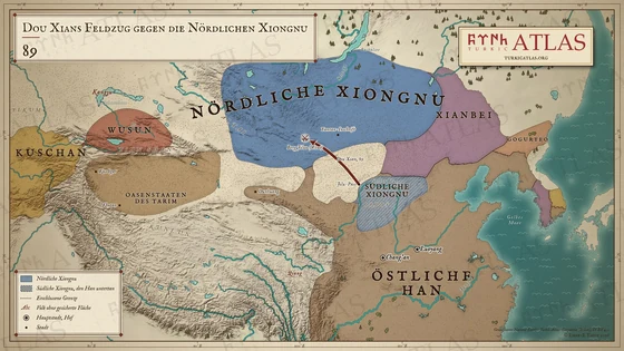
  6. Map of Dou Xian’s campaign in 89: the Northern Xiongnu in the Mongolian steppe, the Southern Xiongnu subject to the Eastern Han, the march from the Jilu pass to the battle at Mount Jiluo in the Altai and the Yanran inscription, with the Xianbei in the east and the Wusun, the oases of the Tarim and the Kushans in the west © Emre-E Yavuz 2026
    89Tafel VI Dou Xians Feldzug gegen die Nördlichen Xiongnu
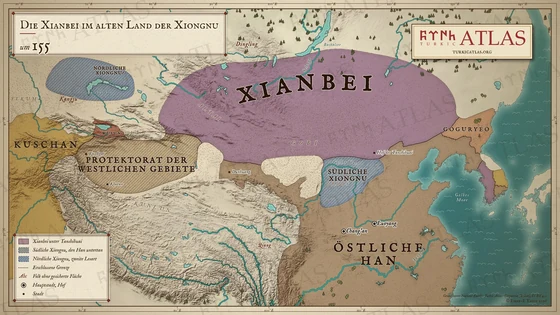
  7. Map of the Xianbei about 155: the realm of Tanshihuai over the Mongolian steppe, the Southern Xiongnu inside the frontier of the Eastern Han, the protectorate of the Western Regions, the Wusun and the Kushans, and Northern Xiongnu north-west of Kangju as a second reading © Emre-E Yavuz 2026
    um 155Tafel VII Die Xianbei im alten Land der Xiongnu

Rouran, Hunnen und Nördliche Wei

395–396 – 523–52811 Karten

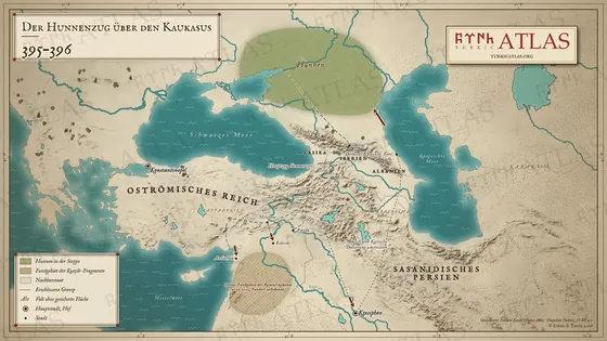
  1. Map of the Hunnic raid of 395–396: the Huns north of the Caucasus, the main raid over the Darial pass to Melitene, Antioch and Edessa, the raid of Basich and Kursich down the Tigris to Ctesiphon and back through Derbent, and the find area of the runic fragments in Syria © Emre-E Yavuz 2026
    395–396Tafel VIII Der Hunnenzug über den Kaukasus
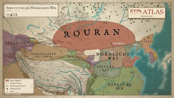
  2. Map of East Asia about 402: the Rouran from Karashahr to Goguryeo, Shelun's raid on the Northern Wei, and in China the Wei, the Later Qin, the Liang states, the Yan states and the Eastern Jin, with the Tuyuhun, the Tarim oasis states, the Wusun and the Kidarites © Emre-E Yavuz 2026
    um 402Tafel IX Shelun und die Nördlichen Wei
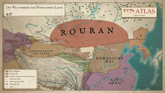
  3. Map of East Asia in 439: the Rouran in the steppe, the Northern Wei with the Northern Liang they took in 439, the march of the Wei from Pingcheng to Guzang, the flight of the Ashina to the Rouran, and the Liu Song in the south © Emre-E Yavuz 2026
    439Tafel X Die Wei nehmen die Nördlichen Liang
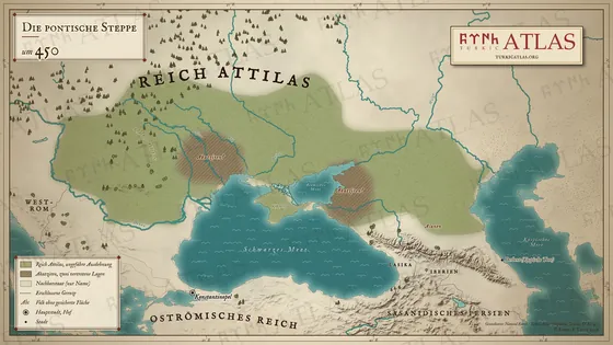
  4. Map of the Pontic steppe around 450: the realm of Attila from the Danube to the Volga, the Akatziri in two proposed places, the Alans north of the Caucasus, and the Eastern Roman Empire and Sasanian Persia as neighbours © Emre-E Yavuz 2026
    450Tafel XI Die pontische Steppe
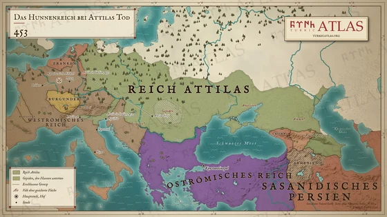
  5. Map of Europe at Attila's death in 453: the Hunnic Empire from the Rhine to the Caspian Sea with the Gepids as subjects, the Western and Eastern Roman Empires, the Visigoths, Franks and Burgundians, Sasanian Persia, and the routes of Attila's campaigns in Gaul in 451 and in Italy in 452 © Emre-E Yavuz 2026
    453Tafel XII Das Hunnenreich bei Attilas Tod
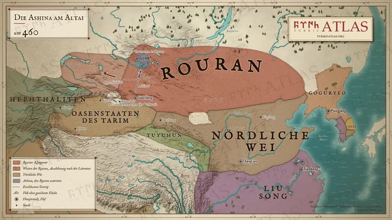
  6. Map of East Asia about 460: the Rouran in the steppe with their hatched reach west to Lake Balkhash, the Ashina as a small subject territory on the southern slope of the Altai, the road of the Ashina from Gaochang, the march of the Rouran against the Tiele, the Northern Wei and the Liu Song in China © Emre-E Yavuz 2026
    um 460Tafel XIII Die Ashina am Altai
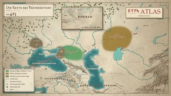
  7. Map of the chain of expulsions around 463: the Abares pressing the Sabirs, the Sabirs pressing the Saragurs, Ogurs and Onogurs west, the defeat of the Akatziri, the embassy of the Saragurs to Constantinople and their later raid through the Caucasus, with an inset of the Rouran © Emre-E Yavuz 2026
    463Tafel XIV Die Kette der Vertreibungen
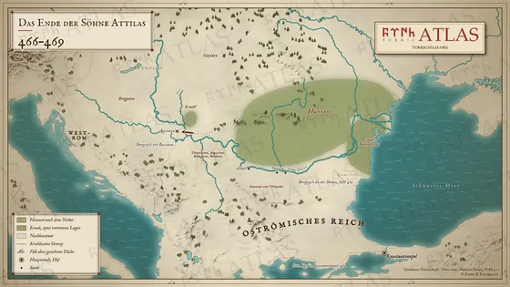
  8. Map of the years 466–469: the Huns after the Nedao on the lower Danube, Dengizich's march against Bassiana, Ernak in two proposed places at the mouth of the Tisza and in the Dobruja, Emnetzur and Ultzindur on the Danube, and the death of Dengizich in 469 © Emre-E Yavuz 2026
    466–469Tafel XV Das Ende der Söhne Attilas
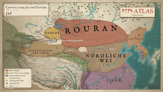
  9. Map of East Asia in 516: the Rouran under Chounu, his campaign west against the Gaoche, the Ashina in the Altai as subjects of the Rouran, the Northern Wei and the Liang in China, the Tuyuhun, the Tarim oasis states and the Hephthalites © Emre-E Yavuz 2026
    516Tafel XVI Chounu schlägt die Gaoche
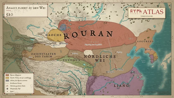
  10. Map of East Asia in 520: the Rouran in civil war, Anagui's flight to the Northern Wei at Luoyang, the independent Gaoche, the Ashina in the Altai, the Northern Wei and the Liang, the Tuyuhun and the Tarim oasis states © Emre-E Yavuz 2026
    520Tafel XVII Anagui flieht zu den Wei
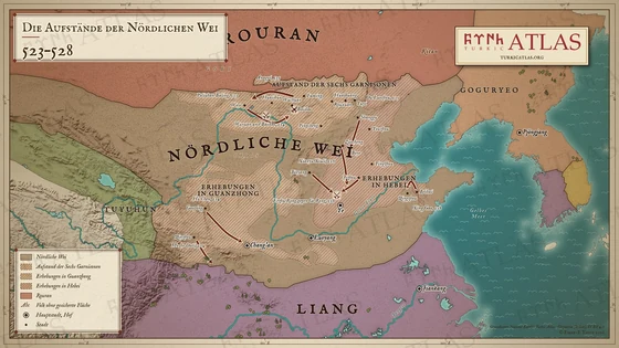
  11. Map of northern China, 523 to 528: the revolt of the Six Garrisons along the northern frontier of the Northern Wei from Woye to Yuyi, the risings in Guanzhong around Chang'an and in Hebei, Anagui's march with the Rouran from Wuchuan against Woye in 525, and Erzhu Rong against Ge Rong at Ye in 528 © Emre-E Yavuz 2026
    523–528Tafel XVIII Die Aufstände der Nördlichen Wei

Der Aufstieg der Göktürken

um 542 – 55610 Karten

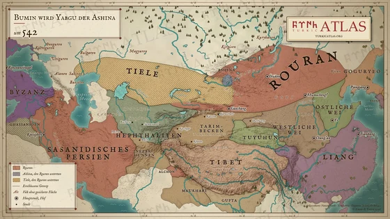
  1. Map of Asia around 542: the Rouran Khaganate across the eastern steppe, with the Ashina in the Altai and the Tiele from Dzungaria to the Caspian as its subjects, beside the Western and Eastern Wei, the Liang, the Tuyuhun, the Tarim Basin, the Hephthalites, the Nezak Huns, Sasanian Persia, the Eastern Roman Empire and Goguryeo © Emre-E Yavuz 2026
    um 542Tafel XIX Bumin wird Yabgu der Ashina
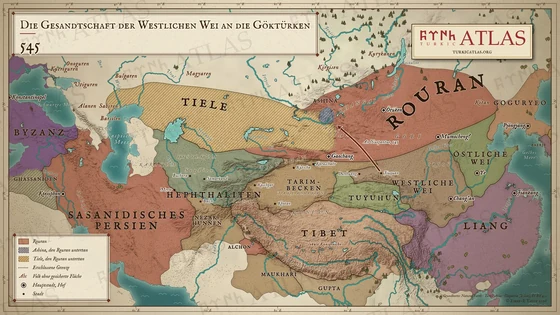
  2. Map of Asia in 545: the embassy of the Western Wei under An Nuopantuo from Jiuquan to the Ashina in the Altai, subjects of the Rouran, who rule the eastern steppe with the Tiele as further subjects, beside the Western and Eastern Wei, the Liang, the Tuyuhun, the Hephthalites, Sasanian Persia and the Eastern Roman Empire © Emre-E Yavuz 2026
    545Tafel XX Die Gesandtschaft der Westlichen Wei zu den Göktürken
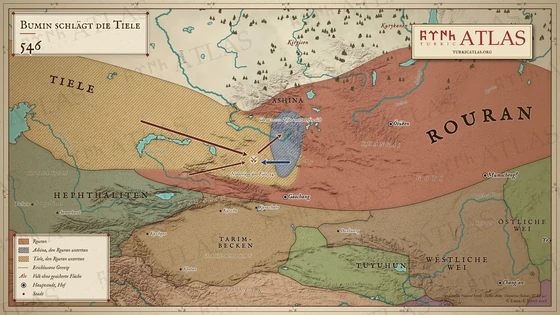
  3. Map of the defeat of the Tiele in 546: the Tiele move from Dzungaria against the Rouran, Bumin and the Ashina strike them from the Altai, and the beaten Tiele pass into the Ashina territory, which reaches south towards Turfan, within the Rouran Khaganate © Emre-E Yavuz 2026
    546Tafel XXI Bumin schlägt die Tiele
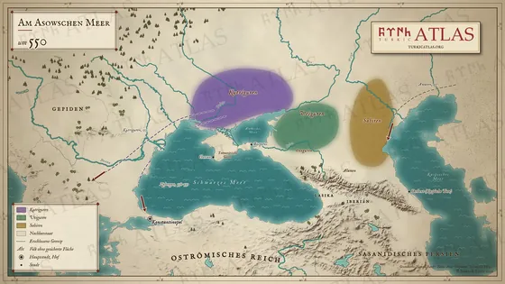
  4. Map of the Sea of Azov around 550: the Kutrigurs west and the Utigurs east of the Don, the Sabirs and Onogurs north of the Caucasus, Bosporos and Cherson in the Crimea, the Kutrigur raids of 551 and 558–559, and the arrival of the Avars in 557 © Emre-E Yavuz 2026
    550Tafel XXII Am Asowschen Meer
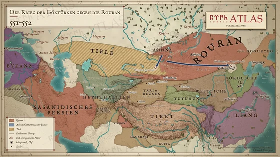
  5. Map of the Göktürk–Rouran war of 551 and 552: from the Altai the Ashina under Bumin strike a Rouran army in Dzungaria and drive east across the Gobi to Huaihuang, where Anagui kills himself; the Rouran rule the eastern steppe, the Tiele are their subjects in the west © Emre-E Yavuz 2026
    551–552Tafel XXIII Der Göktürk-Rouran-Krieg
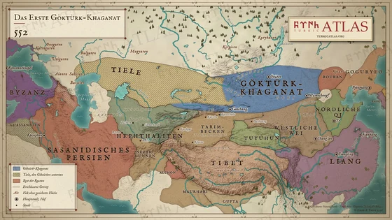
  6. Map of Asia in 552: the First Göktürk Khaganate across the eastern steppe from the Altai to the Khingan, south of Lake Baikal, the Tiele in the west as its subjects, the remnant of the Rouran in the east, beside the Western Wei, the Northern Qi, the Liang, the Tuyuhun, the Hephthalites and Persia © Emre-E Yavuz 2026
    552Tafel XXIV Das Erste Göktürk-Khaganat
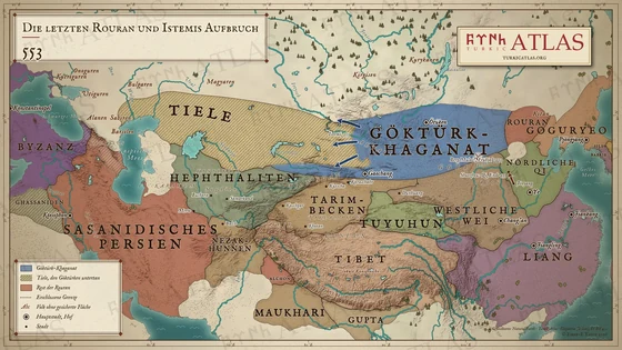
  7. Map of Asia in 553: the Göktürk Khaganate with the Tiele as subjects, the battle at Mount Mulai against the last Rouran, the march of the Qi to Shuozhou, and Istemi's first advances west from the Altai, with the Western Wei, the Northern Qi, the Hephthalites and Sasanian Persia © Emre-E Yavuz 2026
    553Tafel XXV Die letzten Rouran und Istemis Aufbruch
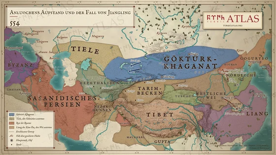
  8. Map of Asia in 554: the Göktürk Khaganate with the Tiele as subjects, the Rouran remnant between the Göktürks and the Northern Qi, the Qi pursuit to the Huanggua hill, the fall of Jiangling to the Western Wei, and Istemi's advance in the west © Emre-E Yavuz 2026
    554Tafel XXVI Anluochens Aufstand und der Fall von Jiangling
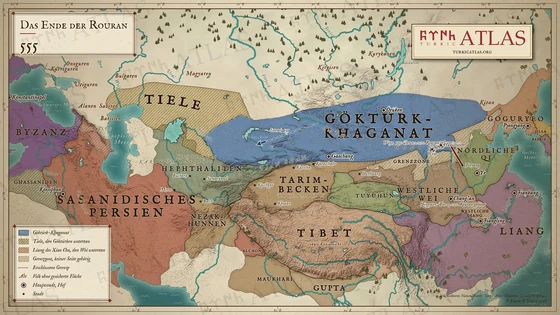
  9. Map of Asia in 555: the Göktürk Khaganate reaching Lake Balkhash, the Qi campaign to Huaishuo and Woye against the last Rouran, the killing of the Rouran at the Qingmen gate of Chang'an, and the frontier zone between the Göktürks and China © Emre-E Yavuz 2026
    555Tafel XXVII Das Ende der Rouran
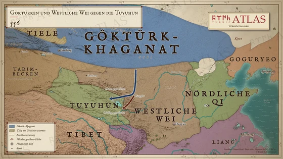
  10. Map of the campaign against the Tuyuhun in 556: Mukan's march from the steppe by Liangzhou to the Qinghai lake and on the northern road against Hezhen, Shi Ning's march against Shudun, the Göktürk Khaganate, the Western Wei, the Northern Qi with their wall and the Liang © Emre-E Yavuz 2026
    556Tafel XXVIII Göktürken und Westliche Wei gegen die Tuyuhun

Das Erste Göktürk-Khaganat

557 – 5767 Karten

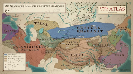
  1. Map of Asia in 557: the Göktürk Khaganate from Lake Balkhash to the land of the Khitan, the Tiele as subjects, the Northern Zhou, the Northern Qi and the Chen, and the flight of the Avars west to the Alans north of the Caucasus © Emre-E Yavuz 2026
    557Tafel XXIX Die Nördlichen Zhou und die Flucht der Awaren
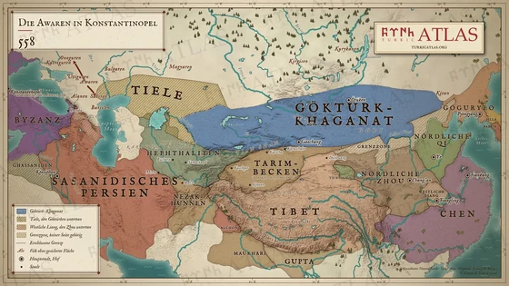
  2. Map of Asia in 558: the road of the first Avar embassy through the Alans and Lazica to Constantinople, the Avar attacks on the Onogurs and the Sabirs, and the Göktürk Khaganate from Lake Balkhash to the land of the Khitan © Emre-E Yavuz 2026
    558Tafel XXX Die Awaren in Konstantinopel
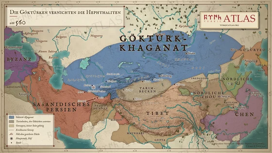
  3. Map of Asia around 560: the Göktürk Khaganate from Manchuria to the Caspian, Istemi advancing through Chach to the battle of Bukhara, Khosrow I advancing from the south to Balkh, beside Sasanian Persia, the Northern Zhou, the Northern Qi and the Chen © Emre-E Yavuz 2026
    um 560Tafel XXXI Die Göktürken vernichten die Hephthaliten
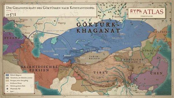
  4. Map of the return of Zemarchos with the Göktürk embassy under Tagma Tarkhan, 569 to 571: from Talas north of the Aral Sea across the Emba, the Ural and the Volga, through the lands of the Alans and over the Caucasus to the Black Sea and Constantinople © Emre-E Yavuz 2026
    um 571Tafel XXXII Die Gesandtschaft der Göktürken nach Konstantinopel
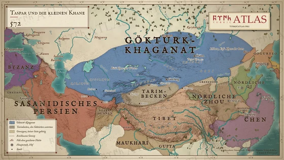
  5. Map of Asia in 572: the Göktürk Khaganate under Taspar Khan, with Ishbara as Erfu Khan in the east and Börü Khan in the west, the Tarim Basin as subject, the Northern Zhou, the Northern Qi and the Chen in China, and Sasanian Persia © Emre-E Yavuz 2026
    572Tafel XXXIII Taspar und die kleinen Khane
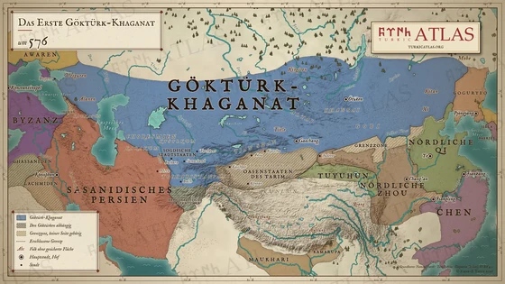
  6. Map of the First Göktürk Khaganate around 576: the Göktürk realm across the steppe from the Black Sea, the Utigurs and the Alans to the Khitan, with the court at Ötüken, the Tarim oasis states and the Hephthalite principalities as tributaries, the Kirghiz, Tiele, Shiwei and Mohe at its northern and eastern edges, and beside it the Eastern Roman Empire, Sasanian Persia, the Tuyuhun, the Northern Zhou, the Northern Qi, the Chen and Goguryeo, and between the steppe and China the wall of the Northern Qi and a hatched frontier zone © Emre-E Yavuz 2026
    um 576Tafel XXXIV Das Erste Göktürk-Khaganat
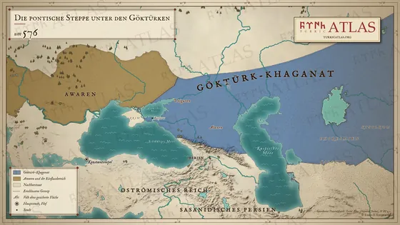
  7. Map of the Pontic steppe in 576: the Göktürk Khaganate from the Sea of Azov to the Aral Sea with Bosporos, the Utigurs and the Alans, and the Avars and their sphere west of the Don © Emre-E Yavuz 2026
    576Tafel XXXV Die pontische Steppe unter den Göktürken

Teilung und Bürgerkrieg

581 – um 6039 Karten

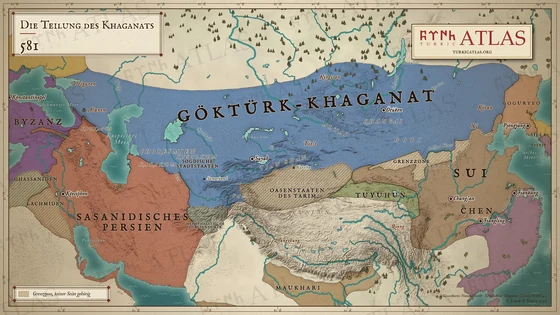
  1. Map of Asia in 581: the undivided Göktürk Khaganate from the Black Sea to the Khitan with the court at Ötüken, the Tarim oasis states and the Hephthalite principalities as tributaries, beside the Eastern Roman Empire, Sasanian Persia, the Sui, the Chen, the Tuyuhun and Goguryeo, and between the steppe and China the wall of the Northern Qi and a hatched frontier zone © Emre-E Yavuz 2026
    581Tafel XXXVI Die Teilung des Khaganats
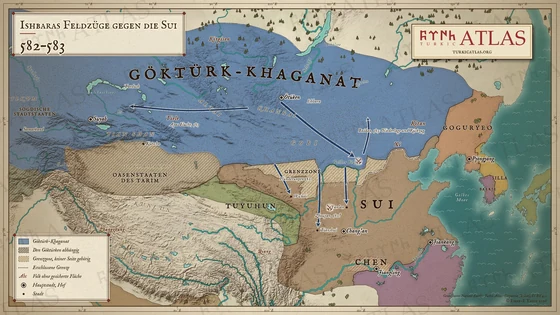
  2. Map of northern China and the eastern steppe, 582 to 583: the Göktürk Khaganate from the Tarim to the Khingan, three raids across the Long Wall in 582 towards Wuwei, Tianshui and Yan'an, the battle of Zhoupan, Ishbara's march from Ötüken to Baidao in 583, his defeat and withdrawal, and Apa's flight west © Emre-E Yavuz 2026
    582–583Tafel XXXVII Ishbaras Feldzüge gegen die Sui
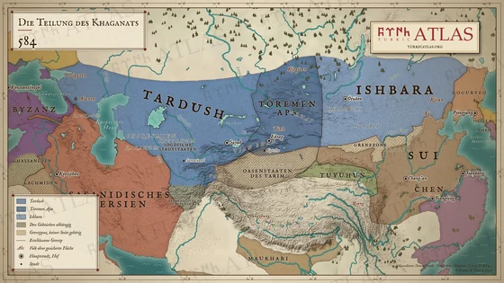
  3. Map of Asia in 584 during the Göktürk civil war: the zones of Tardush in the west, Töremen Apa in the middle and Ishbara in the east, the Tarim oasis states and the Hephthalite principalities as tributaries, beside the Eastern Roman Empire, Sasanian Persia, the Sui, the Chen, the Tuyuhun and Goguryeo, and between the steppe and China the wall of the Northern Qi and a hatched frontier zone © Emre-E Yavuz 2026
    584Tafel XXXVIII Die Teilung des Khaganats
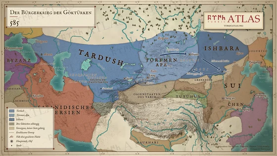
  4. Map of the Göktürk civil war in 585: Tardush in the west from the Black Sea to Suyab, Töremen Apa between the Tian Shan and Ötüken, Ishbara in the east, the advance on Ötüken in September 585, Ishbara's withdrawal to Baidao under Sui protection and his counterattack against Apa, with the Tarim oasis states as tributaries and the Sui to the south © Emre-E Yavuz 2026
    585Tafel XXXIX Der Bürgerkrieg der Göktürken
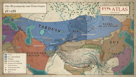
  5. Map of the Göktürk civil war, 587 to 588: Tardush in the west, Niri in Apa's following between the Tian Shan and the Khangai, the eastern khaganate under Bagha and from 588 under Tulan, Bagha's march west in 587 in which Apa was taken alive, and the war with Persia in 588, with the Sui and the Chen to the south © Emre-E Yavuz 2026
    587–588Tafel XL Der Bürgerkrieg der Göktürken
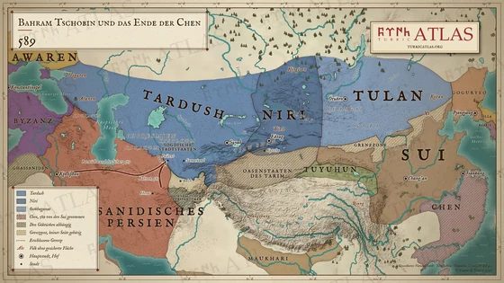
  6. Map of Asia in 589: Bahram Chobin's march from Herat to Paikent and the road of Parmūdha and the treasure to Ctesiphon, the Göktürks divided into Tardush, Niri and the eastern khaganate under Tulan, the Sui and the Chen they took in 589, Sasanian Persia and Byzantium © Emre-E Yavuz 2026
    589Tafel XLI Bahram Tschobin und das Ende der Chen
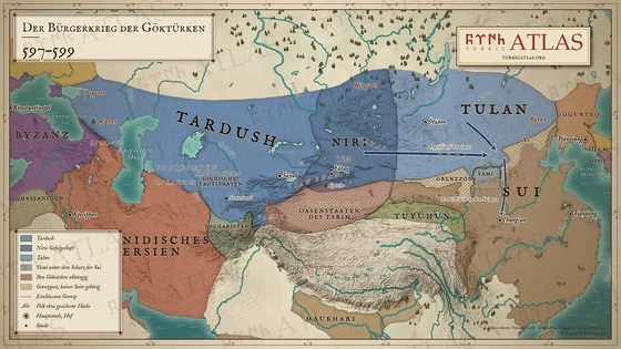
  7. Map of the Göktürk civil war, 597 to 599: Tardush in the west, Niri between the Tian Shan and the Khangai, Tulan in the east, Yami's pastures in the Ordos under Sui protection, the attack of Tulan and Tardush on Yami below the Long Wall in 599 and Yami's flight to Chang'an © Emre-E Yavuz 2026
    597–599Tafel XLII Der Bürgerkrieg der Göktürken
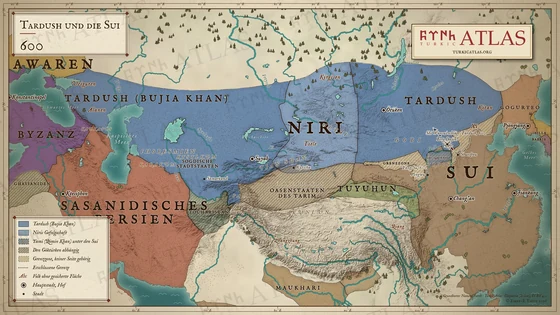
  8. Map of Asia in 600: Tardush as Bujia Khan over the steppe from the Black Sea to Manchuria, Niri's following in the Altai, Yami under the Sui in the Ordos, and the Sui columns to Mount Dajin © Emre-E Yavuz 2026
    600Tafel XLIII Tardush und die Sui
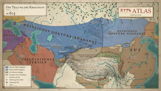
  9. Map of Asia around 603: the Western Göktürk Khaganate from the Black Sea to the Tian Shan and the Eastern Göktürk Khaganate from the Khangai to the Khitan, the Tarim oasis states and the Hephthalite principalities as tributaries of the west, beside the Eastern Roman Empire, Sasanian Persia, the Sui, the Tuyuhun and Goguryeo, and between the steppe and China the wall of the Northern Qi, Yami's pasture in the Ordos and a hatched frontier zone © Emre-E Yavuz 2026
    um 603Tafel XLIV Die Teilung des Khaganats

Die Tang und der Aufstieg des Zweiten Göktürk-Khaganats

627 – 68210 Karten

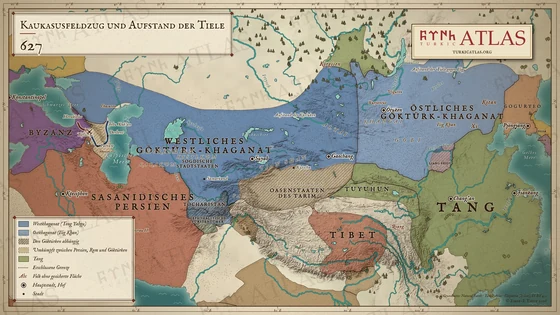
  1. Map of Eurasia in 627: the western Göktürk khaganate under Tong Yabgu from the Caucasus to the Tarim, the march of Jebu Xak'an through Derbent to Tiflis and of Heraclius to the siege of Tiflis, the eastern Göktürk khaganate under Ilig Khan with the revolt of the Tiele, the Tang, Tibet, Sasanian Persia and Byzantium © Emre-E Yavuz 2026
    627Tafel XLV Der Kaukasusfeldzug und der Aufstand der Tiele
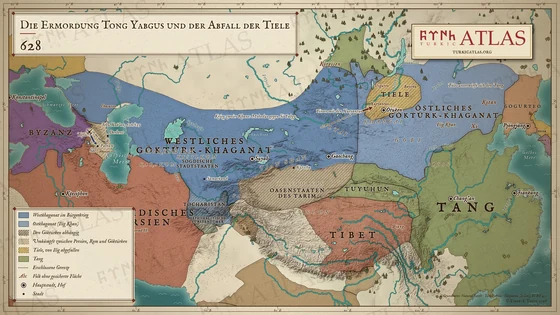
  2. Map of Eurasia in 628: the western Göktürk khaganate in the war of two khans, the Xueyantuo under Yinan moving east from the Altai, the Tiele between the Khangai and the Selenga fallen away from the eastern khaganate of Ilig Khan, the second march of Jebu Xak'an to Tiflis, the Tang, Tibet, Sasanian Persia and Byzantium © Emre-E Yavuz 2026
    628Tafel XLVI Die Ermordung Tong Yabgus und der Abfall der Tiele
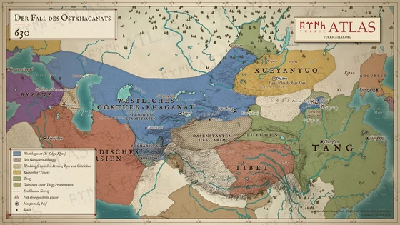
  3. Map of Eurasia in 630: Li Jing's attack on Dingxiang and his victory at the Iron Mountain north of the Yin Mountains, the Göktürks under Tang protectorates along the Yellow River, the Xueyantuo north of the Gobi, Yiwu with the Tang, the western Göktürk khaganate under Si Yabgu Khan and the battle at Lake Sevan © Emre-E Yavuz 2026
    630Tafel XLVII Der Fall des Ostkhaganats
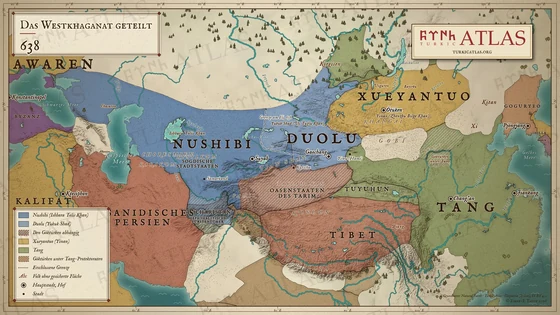
  4. Map of Asia in 638: the western Göktürk khaganate divided at the Ili between the Nushibi under Ishbara Tolis Khan and the Duolu under Yukuk Shad, with the Xueyantuo, the Tang and the Caliphate © Emre-E Yavuz 2026
    638Tafel XLVIII Das Westkhaganat geteilt
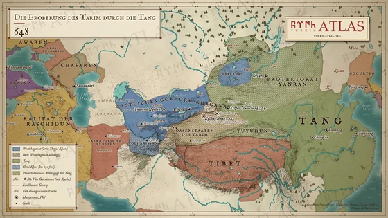
  5. Map of Central Asia in 648: the Tang advance from Xizhou (Gaochang) by Karashahr to Kucha, the seat of the Anxi protectorate, the Four Garrisons of Kucha, Khotan, Kashgar and Suyab, the western Göktürk khaganate under Irbis Shegui Khan, Chebi Khan in the Altai and the Yanran protectorate © Emre-E Yavuz 2026
    648Tafel XLIX Die Eroberung des Tarim durch die Tang
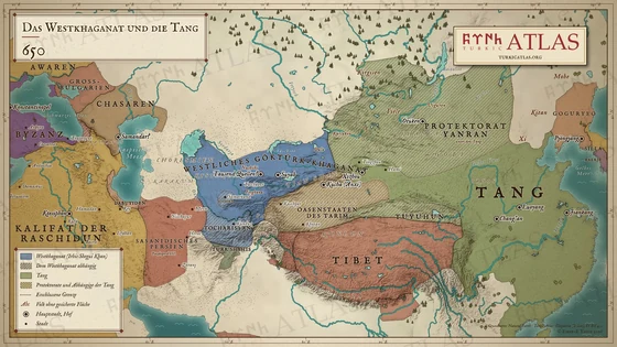
  6. Map of Asia in 650: the Western Göktürk Khaganate from the Tarbagatai to the Oxus with Sogdia and Tokharistan as dependants, the Tang with the protectorate of Yanran over the steppe, the Kirghiz and the oasis states of the Tarim as tributaries, beside Tibet, the Tuyuhun, the Korean kingdoms, Japan, the Rashidun Caliphate, the rest of Sasanian Persia, the Khazars, Great Bulgaria, the Avars and the Eastern Roman Empire © Emre-E Yavuz 2026
    650Tafel L Das Westliche Khaganat und die Tang
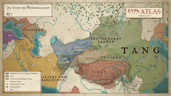
  7. Map of Asia in 657: the land of the western Göktürks as ten prefectures under the Tang, the Yanran protectorate in the steppe, the Tarim oases, Tibet and the Rashidun Caliphate up to the Oxus © Emre-E Yavuz 2026
    657Tafel LI Das Ende des Westkhaganats
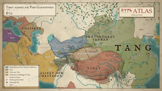
  8. Map of Asia in 670: the Tarim oases under Tibet, with an arrow to Kucha, the Tang and their protectorates, the western Göktürks under the Tang and the Umayyad Caliphate © Emre-E Yavuz 2026
    670Tafel LII Tibet nimmt die Vier Garnisonen
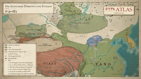
  9. Map of northern China and the steppe, 679 to 681: the Göktürks of the Ordos and of Yunzhong in revolt, Pei Xingjian's marches from Chang'an to Black Mountain and into the west against Ashina Duzhi, Funian raised at Xiazhou, numbered in the order of events © Emre-E Yavuz 2026
    679–681Tafel LIII Die Aufstände Nishufus und Funians
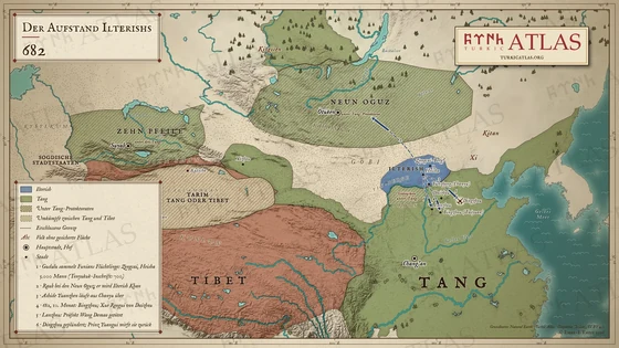
  10. Map of northern China and the steppe in 682: the land of Ilterish north of the Yellow River with Heisha and Zongcai Mountain, his raid on the Nine Oguz and the raids on Bingzhou, Lanzhou and Dingzhou, numbered in the order of events © Emre-E Yavuz 2026
    682Tafel LIV Der Aufstand Ilterishs

Das Zweite Göktürk-Khaganat

691 – 7348 Karten

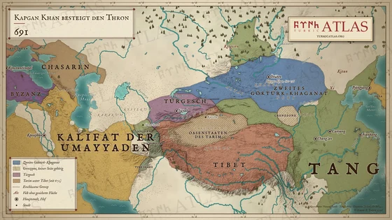
  1. Map of Asia in 691: the Second Göktürk Khaganate in Mongolia under Kapgan Khan, the Türgesh around Suyab, the Tarim under Tibet, the Tang and the Umayyad Caliphate © Emre-E Yavuz 2026
    691Tafel LV Kapgan Khan besteigt den Thron
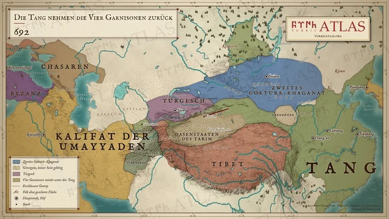
  2. Map of Asia in 692: the Tarim oases again under the Tang, with Wang Xiaojie's march to Kucha, the Second Göktürk Khaganate, the Türgesh and Tibet © Emre-E Yavuz 2026
    692Tafel LVI Die Tang nehmen die Vier Garnisonen zurück
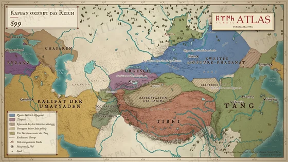
  3. Map of Asia in 699: the Second Göktürk Khaganate under Kapgan Khan, the Türgesh under Wuzhile around Suyab, Tang China and Tibet © Emre-E Yavuz 2026
    699Tafel LVII Kapgan ordnet das Reich
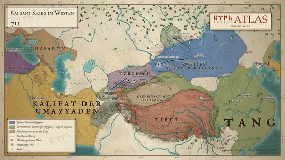
  4. Map of Asia in 710–711: the Second Göktürk Khaganate with the Kirghiz, the Türgesh and the Sogdians as subjects, and the campaigns over the Kögmen, to Bolchu and to the Iron Gate © Emre-E Yavuz 2026
    711Tafel LVIII Kapgans Krieg im Westen
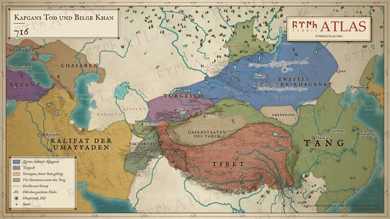
  5. Map of Asia in 716: Kapgan Khan killed on the Tola, Bilge Khan on the throne of the Second Göktürk Khaganate, the Türgesh, Tang China and Tibet © Emre-E Yavuz 2026
    716Tafel LIX Kapgans Tod und Bilge Khan
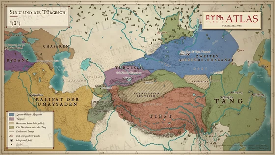
  6. Map of Asia in 717: Sulu khan of the Türgesh, Bilge Khan in the Second Göktürk Khaganate, the Arab siege of Constantinople © Emre-E Yavuz 2026
    717Tafel LX Sulu und die Türgesch
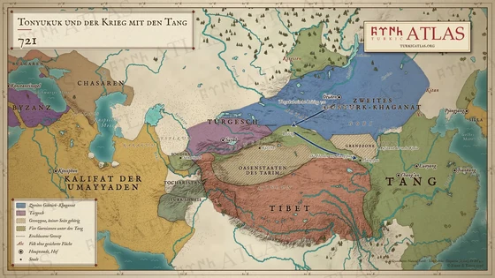
  7. Map of Asia in 721: Tonyukuk takes Beiting and raids Liangzhou, the revolt of the six counties in the Ordos © Emre-E Yavuz 2026
    721Tafel LXI Tonyukuk und der Krieg mit den Tang
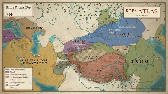
  8. Map of Asia in 734: the death of Bilge Khan, Yiran Khan and Tengri Khan in the Second Göktürk Khaganate, Sulu of the Türgesh © Emre-E Yavuz 2026
    734Tafel LXII Bilge Khans Tod

Uiguren und Kirgisen

744 – 8426 Karten

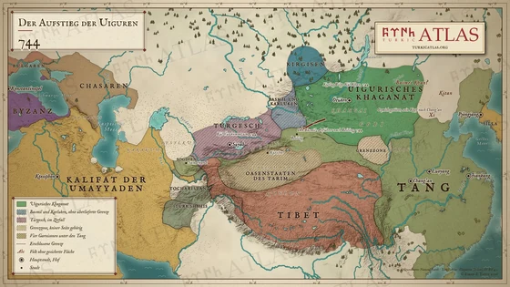
  1. Map of Asia in 744: the Uyghur Khaganate on the Orkhon, the Basmïl and Karluks in the Altai, the Türgesh breaking up, Tang China and Tibet © Emre-E Yavuz 2026
    744Tafel LXIII Der Aufstieg der Uiguren
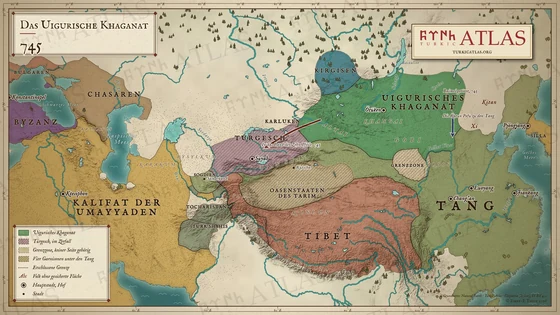
  2. Map of Asia in 745: the Uyghur Khaganate from the Altai to the Shiwei, the Karluks moving west to the Ten Arrows, and the Katun Pofu going to the Tang © Emre-E Yavuz 2026
    745Tafel LXIV Das Uigurische Khaganat
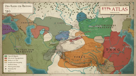
  3. Map of Asia in 790: the Uyghur Khaganate, Beiting lost to Tibet, Anxi cut off from the Tang, the Karluks and the Abbasid Caliphate © Emre-E Yavuz 2026
    790Tafel LXV Der Krieg um Beiting
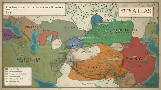
  4. Map of Asia in 821: the Uyghur Khaganate at war with the Kirghiz, the road of Tamim ibn Bahr, the Tibet–Tang treaty © Emre-E Yavuz 2026
    821Tafel LXVI Das Khaganat im Krieg mit den Kirgisen
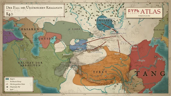
  5. Map of Asia in 840: the Kirghiz destroy Ordu-Baliq, and the Uyghurs flee to the Tang frontier, to Gansu, to the Tarim and to the Karluks; the steppe is left empty © Emre-E Yavuz 2026
    840Tafel LXVII Der Fall des Uigurischen Khaganats
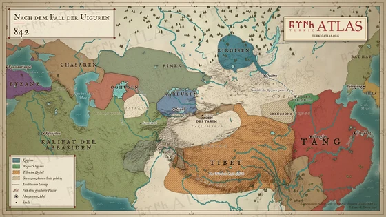
  6. Map of Asia in 842: Wujie's Uyghurs on the Tang frontier, the Kirghiz in the north, the Tibetan empire breaking up © Emre-E Yavuz 2026
    842Tafel LXVIII Nach dem Fall der Uiguren

Die türkischen Staaten

Die Staaten, die Turkvölker gründeten oder beherrschten, 24 insgesamt, von 209 v. Chr. bis 1240, in der Reihenfolge ihrer Gründung. Jede Zeile kommt aus ihrem Artikel und führt dorthin.


Nr.EmblemStaatJahreDauerHerrscherhausGründerHauptstadtHerrschertitel
1 Xiongnu 匈奴 um 209 v. Chr.–155 um 364 Jahre Luandi Modu Chanyu (Mete Han) – Chanyu
2 Hunnenreich um 370–469 um 99 Jahre – – – King
3 Reich der Gaoche 高車 um 487–541 um 54 Jahre Fufuluo Afuzhiluo – Great son of heaven, King
4 Erstes Göktürk-Khaganat 𐱅𐰇𐰼𐰜: 𐰉𐰆𐰑𐰣 突厥 552–630 78 Jahre Ashina Bumin Khan, Istemi Ötüken Khan (Khagan)
5 Westliches Göktürk-Khaganat on oq 西突厥 um 552–657 um 105 Jahre Ashina Istemi Suyab Yabgu
6 Xueyantuo-Khaganat (Syr Tardush) Sır Tarduš 薛延陀 628–646 18 Jahre – Yinan Khan Ötüken Khan (Khagan)
7 Altes Grossbulgarien um 635–660 um 25 Jahre – Kubrat – –
8 Chasarisches Khaganat *Qazar 可薩 um 650–969 um 319 Jahre Ashina – Itil Khan (Khagan)
9 Donaubulgarien 681–? – Dulo Asparuch Pliska Khan (Khagan)
10 Zweites Göktürk-Khaganat 𐱅𐰇𐰼𐰜: 𐰉𐰆𐰑𐰣 突厥 682–744 62 Jahre Ashina Ilterish Khan, Tonyukuk Ötüken Khan (Khagan)
11 Türgesch-Khaganat 突騎施 um 699–744 um 45 Jahre – Wuzhile Suyab Khan (Khagan)
12 Uigurisches Khaganat 回紇 744–840 96 Jahre Yaglakar Kutlug Bilge Kül Khan Ordu-Balık Khan (Khagan)
13 Karluk-Yabgu-Staat um 745–? – – – Suyab Yabgu
14 Jenissei-Kirgisen-Khaganat 黠戛斯 um 840–924 um 84 Jahre Are Are Khan Kemijkat Khan (Khagan), Aco
15 Karachanidisches Khanat um 840–1212 um 372 Jahre – – – Khan (Khagan)

It is not the time, yet...

Die Steppe vor den Göktürken

Völker und Reiche der Steppe vor 552, bis zu den Rouran, die die Göktürken stürzten. Skythen, Saken und Sarmaten sprachen iranische Sprachen. Bei den übrigen ist die Sprache unbekannt oder umstritten.

Nr.EmblemStaatJahreDauerHerrscherhausGründerHauptstadtHerrschertitel
1 Kimmerier um 1000 v. Chr.–600 v. Chr. um 400 Jahre – – – –
2 Saken 塞 um 800 v. Chr.–100 v. Chr. um 700 Jahre – – – –
3 Skythen um 800 v. Chr.–300 v. Chr. um 500 Jahre Royal Scythians – – –
4 Sarmaten um 400 v. Chr.–400 um 800 Jahre – – – –
5 Donghu 東胡 um 300 v. Chr.–206 v. Chr. um 94 Jahre – – – King
6 Yuezhi 月氏 um 209 v. Chr.–130 v. Chr. um 79 Jahre – – – King
7 Wusun 烏孫 um 130 v. Chr.–? – – – Red valley city Kunmo
8 Xianbei 鮮卑 um 87–235 um 148 Jahre – – – Chief
9 Rouran-Khaganat Apar 柔然 um 400–554 um 154 Jahre Yujiulü Shelun Khan Mumocheng Khan (Khagan)

Fünf Sprachen

Der Atlas in deiner Sprache

Menüs, Chronologien und bewegte Karten stehen in allen fünf Sprachen, dazu 304 Artikel.

Neu, Grundstufe:OʻzbekchaҚазақшаКыргызча